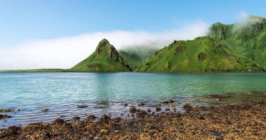
Disputes over the territorial affiliation of the Kuril Islands have been ongoing for many decades. Both Russia and Japan consider them to be their own, but control of the Kuril Islands remains with our country for a long time. And this, by the way, is a very interesting place! With unique nature and rich history. Unfortunately, getting here is not easy, but it’s worth it.
Japan officially attributes the southern islands of the archipelago to its territories, to Hokkaido Prefecture. In Russia, the Kuril Islands are equated to areas of the Far North, although the southern part of the archipelago lies on the latitude of the Black Sea. But the climate on most of the islands there is indeed quite severe, sometimes even close to the Arctic. The Kuril archipelago includes 56 islands, of which about thirty have an area of more than 1 square kilometer. The Kuril Islands chain is a natural border between the Pacific Ocean and the Sea of Okhotsk. The highest point of the Kuril Islands is Alaid Volcano, the peak of which rises to a height of 2339 meters. The last time he erupted in 1997. The Kurile Islands has the world’s richest deposit of rhenium, a rare and very valuable metal. It is home to 84 species of animals included in the Russian Red Book. The native population of the islands, the Ainu, has almost disappeared today. In Russia, about a hundred representatives of this people are registered.
The name “Kuril Islands” came to the Russian language from the language of the Ainu, whose word “Kuru” simply means “man”. Russia and Japan have been competing over the Kuril Islands for several hundred years, back in the 18th century. The reserves of gold and silver in the Kuril Islands are estimated at more than 1800 tons and 9200 tons, respectively. And the iron there, according to geologists, is more than 230 million tons. In 1952, the most powerful tsunami that hit the Kuril archipelago actually destroyed the city of Severokurilsk. The catastrophe was terrifying, and the Soviet media forbade even mentioning it. There is a permanent population on only four islands of the archipelago. In total, there are 19 settlements in the Kuril Islands, in which about 20 thousand people live in total. Since they belong to the border zone, even Russians need to receive a special pass in Yuzhno-Sakhalinsk to visit the Kuril Islands. The only connection with the outside world for the local population is the ferry that goes to Sakhalin twice a week, and the plane from Iturup to Sakhalin, which flies five times a week. There are only five hotels throughout the archipelago, in which there are a total of about 70 rooms. Moreover, during the days of visits of Japanese tourists to Russians, rooms are rented out extremely reluctantly.
The lion’s mouth bay on Iturup island has a depth of 500 meters, because it is a crater of an extinct underwater volcano. There is a waterfall called Ilya Muromets, one of the highest in Russia – 141 meters. On the island of Kunashir there is a boiling lake Ponto, the water in which in some places has a temperature above 100 degrees. At the bottom of the lake beat numerous thermal springs. In addition, its waters contain a large amount of heavy metals, so swimming is not worth it. The Kurile island of Matua is growing from time to time, because the Sarychev volcano located on it often erupts. Stiffening, lava expands the island. An ancient yew is growing in the Kuril Islands, which is already more than a thousand years old. Locals respectfully call this tree “Sage”. The species of raven inhabiting here is very strange croaking. It seems that the birds do not croak, but laugh ominously. There are Kurilian Bobtail, an interesting breed of cats, characterized by a short tail. The weather in the Kuril Islands can easily change dramatically ten to twenty times a day.