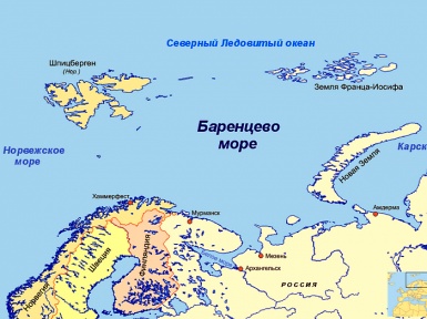
Barents Sea – washes the northern coast of the Scandinavian and Kola Peninsulas, Norway and Russia. It is the marginal sea of the Arctic Ocean.From the north it is limited by the Svalbard and Franz Josef Land archipelagos, from the east by the Novaya Zemlya archipelago. The area of the Barents Sea – 1424 thousand sq. Km. Volume – 282 thousand cubic meters. km Depth: medium – 220 m. Maximum – 600 m. Borders: in the west with the Norwegian Sea, in the south with the White Sea, in the east with the Kara Sea.
The northern seas have long attracted Russian people with their wealth. The abundance of fish, marine animals and birds, despite the icy water, long and cold winters, made this region quite suitable for a well-fed stay. And when a person is full, then the cold does not matter to him.
In the old days, the Barents Sea was called the Arctic, then Siversky or Severny, sometimes it was called Pechora, Russian, Moscow, but often Murmansk, according to the ancient name of the Pomeranian (Murmansk) land. It is believed that the first Russian lodges in the waters of the Barents Sea sailed back in the 11th century. Around the same time, Viking boats began to swim here. And then trade settlements began to appear in the north of Russia, and fishing began to develop.
Before Russia gained a full-fledged fleet capable of overcoming the expanses of the northern seas, the most northern Russian city was Arkhangelsk. Founded by decree of Tsar Ivan the Terrible in 1583-1584 near the Mikhailo-Arkhangelsk monastery, the small town became the main Russian port where foreign sea vessels began to call. An English colony even settled there.
This city, located at the mouth of the Northern Dvina flowing into the White Sea, was very attractive to Peter I, and over time it became the Northern Gate of Russia. It was Arkhangelsk that was honored to play a leading role in the creation of the Russian merchant and navy. Peter in 1693 founded the Admiralty in the city, and founded a shipyard on the island of Solombala.
Already in 1694, the ship “St. Pavel ”- the first merchant ship of the Russian Northern Fleet. “St. Paul” had on board 24 guns, which Peter personally cast at the plant in Olonets. To equip the first ship, Peter himself carved rigging blocks. Launching of “St. Paul” was carried out under the direct supervision of Peter. “St. Paul” was issued a “travel certificate” for the right to trade abroad. The ship “St. Paul” was the first of six three-deck merchant ships launched from the sovereign shipyard from 1694 to 1701. Since then, Arkhangelsk has become the center of all foreign trade activity of the Russian state. It was from here that the Russian North began to develop.
Of course, even before the time of Peter the Great, there existed a number of estuaries of the mouth of the Northern Dvina, the White Sea and the coastal part of the Siversky Sea, which were inherited by local pilots. But under Peter these maps were clarified and allowed the rather large ships to safely run aground or reef, which are numerous in these waters.
These places were very attractive for navigation because of their peculiarity, because the sea did not freeze here, thanks to the Gulf Stream, whose warm waters reached these northern shores. This made it possible for ships to pass west into the waters of the Atlantic and further south to the shores of America, Africa, and India. But the lack of sea ships, and a short navigation time impeded the development of the waters of the North Sea. Only rare vessels of brave sailors reached the shores of Spitsbergen and Franz Josef Land, which separated the North Sea from the vast expanses of the Arctic Ocean.
The study of the Barents Sea began in the XVI-XVII centuries, during the era of the Great geographical discoveries. Finding trade routes, European sailors tried to go east to go around Asia to get to China, but could not go far because most of it was covered with ice hummocks that did not melt even during the short northern summer. The Dutch navigator Willem Barents in search of northern trade routes very carefully scouted the waters of the North Sea.
He discovered the Oran Islands, Bear Island, explored Spitsbergen. And in 1597 his ship froze for a long time on the ice. The Barents and their crew left the ship frozen in the ice and on two boats began to make their way to the shore. And although the expedition reached the coast, Willem Barents himself died. Since 1853, this harsh North Sea began to be called in his honor the Barents, although before that it was officially listed on the maps as Murmansk.
Scientific research of the Barents Sea began much later. 1821-1824 Several sea expeditions were undertaken to study the Barents Sea. They were headed by the future president of the St. Petersburg Academy of Sciences, an honorary member of many Russian and foreign scientific institutions, a tireless navigator, Admiral Fedor Petrovich Litke. On sixteen cannon brigade “Novaya Zemlya” he went 4 times to the shores of Novaya Zemlya, examined and described it in detail.