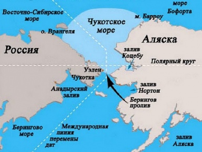
The Chukchi Sea is located on the east of the northern coast of Russia. In the west it borders with the East Siberian Sea, in the east with the Beaufort Sea, in the south with the Bering Sea, it is open to the Arctic Ocean. The area of the Chukchi Sea is 582 thousand square kilometers. Volume 45.4 thousand cubic meters km The average depth is 77 m. Large bays – Kotzebue and Kolyuchinskaya Bay. Islands – Wrangel, Herald and Prickly.
Called the sea of the nation of the people of the Chukchi living in the Chukchi Peninsula. The Chukchi Sea is the latest stage of the Great Northern Sea Route, from which you can go south along the Bering Strait to the Bering Sea of the Pacific Ocean. The sea became navigable after a series of expeditions conducted by Russian researchers. It is considered that the discovery of this route is the result of the First Kamchatka Expedition in 1728 headed by the famous Russian navigator, the Dane Vitus Bering, after whom the strait connecting the Chukchi Sea and then the Kamchatka Sea, later named the Bering Sea, is named. However, this is far from the actual story. Long before that, in 1648 from the mouth of the Kolyma River to the mouth of the Anadyr River, along the northern coast, the real discoverer of this road, Semyon Dezhnev, passed around the Chukotka Peninsula.
Yakut Cossack Semyon Dezhnev was a tribute collector from the local population. To collect the tax, he constantly traveled around the district. In 1642, along the Indigirka River, he reached the Arctic Ocean, then on foot to the mouth of the Kolyma River. There was built Nizhne-Kolyma burg, which became the center of trade. Having learned from the locals that the Anadyr River is considered to be very rich, he and his clerk Fedot Popov on June 20, 1648, on seven horses with a team of more than a hundred people, set off by sea, hoping to reach the mouth of the Anadyr River by sea. For Dezhnev, the goal was to bring local tribes into Russian citizenship and collect yasak from them. Popov was looking for new places to trade.
At the beginning of the hike, the weather accompanied them, and thanks to the fair wind they were able to quickly reach Chukotka. But, not reaching the strait, two cochas were crushed by ice, and two were blown into the ocean. Three kocha under the command of Dezhnev, Popov and Ankudinov rounded the extreme eastern cape Bolshoy Kamenny Nose, which was later called Cape Dezhnev.
With a strong wind, Koch Ankudinova smashed against the coastal cliffs, and the two surviving cochs could land. After a short stay, divided into two remaining Koch, they moved south. The raging storm took the Koch Popov into the sea, and the Kozh Dezhnev washed ashore somewhere south of the mouth of Anadyr. Within two weeks, Dezhnev’s team was able to walk to the mouth of Anadyr, where they had to settle for the winter.
During the heavy wintering half of the team died. In the spring of 1649, out of 25 people, only 12 remained. Having built boats, they climbed to the middle of the river and there they founded Anadyr fortress.
After the hike, S. Dezhnev plotted and gave a description of the Anadyr river basin. After that, he served another 19 years as a tribute collector. And when he arrived in Moscow, he handed over the treasury of 289 pounds of walrus tusk to the sovereign in the amount of 17,340 rubles, for which he gave 126 rubles for handed over yasak and zeal in the service. 20 kopecks silver, and he was granted to atamans. Served S. Dezhnev in Olenyok, in Vilyuy, and Yakutsk until 1670. after which he was again sent to deliver tribute to Moscow, where he arrived in 1671. Dezhnev died there in Moscow in 1673.
A very long time did not know the fate of the team Popov. And only 80 years later, members of the Russian expedition from the locals found out that Popov’s horse had been brought to the shores of Kamchatka, where they had lived for some time. However, because of the famine and the harsh conditions of them no one survived.
After these first attempts to go from the Arctic Ocean to the Pacific Ocean by water, no one has tried for a long time, in any case there is no official information of this kind. In 1728, Vitus Bering passed from the Bering Sea to the Chukchi Sea, and in 1779, Captain James Cook.
The first ship navigator Nils Adolf Erik Nordenskjold passed through the Northern Sea Route in the years 1878-1879 from the Atlantic to the Pacific Ocean on the ship “Vega”. Coming out in July 1878. from Tromso he went through all the northern seas to the Chukchi Sea. But due to the ice situation on September 28, he was forced to stop near the village of Pitlekai in the Kolyuchinskaya Bay and get up there for the winter. The following year, he rounded Chukotka, passed through the strait into the Bering Sea, and then through the Pacific and Indian Ocean, rounding the entire Eurasian continent through the Suez Canal, returned to Sweden.
After that there were several attempts to go this way. In the years 1914-15. B.V. Vilkitsky on the icebreakers Taimyr ”and“ Vaigach ”repeated the campaign of A. Nordenskiold in the opposite direction from Vladivostok to Arkhangelsk.
In 1932, the icebreaker “Sibiryakov” was the first to go all the way in one navigation, thereby proving the possibility of transporting goods along the Northern Sea Route. In 1933, the steamer “Chelyuskin” with the same attempt was crushed by ice in the Chukchi Sea and forced to save the crew with the help of the then developing aircraft. And only with the advent of powerful icebreakers, it was possible to establish navigation along this difficult and dangerous route. Now it is in the order of things, when caravans of ships accompanied by nuclear-powered icebreakers pass along this route in less than a month’s time, and shuttle tankers take several flights for navigation.
The Chukchi Sea is very cold, the temperature of the water is not stable and depends on the cold waters of the Arctic and warmer waters coming through the Bering Strait from the Pacific Ocean, in the summer it stays within 4-12 ° C, in winter it does not exceed 1.6-1.8 ° C. Therefore, the floating ice is a constant picture. Salinity of water from 28 to 32%. The seabed is mostly gravel and loose mud. The rivers flowing into the Chukchi Sea are small, the largest ones are Amguema and Noatak. Large seaports are the Russian Whalen and the American Barrow. Fisheries are limited to only a few species; they are navaga, grayling, polar cod and char. Hunting mainly for walrus, seals and seals.