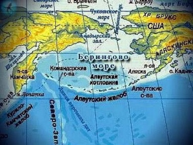
The Bering Sea is the easternmost Russian sea, stretching between Kamchatka and America. Area – 2304 thousand square meters. km Volume – 3683 thousand cubic meters. km The average depth is 1598 meters. In the north, the Bering Sea connects with the Chukchi Sea, in the south it borders on the Aleutian Islands and the open ocean. Many rivers flow into the Bering Sea, the largest ones are Anadyr, Yukon, Apuka. The sea is named after Vitus Jonassen Bering, the head of the Great Northern Expedition.
The history of the discovery and exploration of the Bering Sea goes into the distant past and is associated with the names of the great pioneers who left their names in history for ever.
After the conquest of Siberia by Yermak, the Cossack patrols, and with them many Russian merchants and hunters began to penetrate further east, right up to the very coast of the Pacific Ocean. From them Russian rulers and boyars learned about the untold riches of Eastern Siberia. Fur, red caviar, valuable fish, skins, gold and the wealth of unknown China have become a reason for the rapid development of this region. Since the delivery of these goods by land was fraught with difficulties, they began to think about opening the sea route along the northern coast to get to America, Japan and China by sea.
Peter I paid special attention to this and contributed to this in every way. Even in his last days he gave instructions to General-Admiral Apraksin in which he wrote his orders:
1. It is necessary to make one or two bots with decks on Kamchatka or in another customs place. 2. On these bots near the earth, which goes to the north, and by aspiration (because of this, they don’t know the end) it seems that that land is part of America. 3. And in order to look for where it converged with America; and in order to get to which city of European possessions, or if they see which European ship, check on it, as they call it, take it on the letter, and go on the shore, and take the true register, and put it on the map, come here.
Peter did not live to realize these plans, although in January 1725, just three weeks before his death, he appointed one of the best navigators of that time, Vitus Bering, a Dane who served in the Russian fleet, to head the first Kamchatka expedition. Already after his death, Vitus Bering led an expedition, which by land passed through Siberia to Okhotsk. In winter, the expedition crossed the dogs to Kamchatka, and a ship was built there in Nizhnekamchatsk for a cruise. It was a packboat 18 meters long, 6.1 meters wide, with a draft of 2.3 meters. It was made according to the drawings of the Petersburg Admiralty and at that time was considered one of the best warships. On June 9, 1728, during the launch of the bot, the day of the holy Archangel Gabriel was celebrated and the bot was given the name “Saint Gabriel”.
July 13, 1728 on the bot “St. Gabriel “expedition moved north. During the voyage, a detailed map of the coast and islands was compiled. The weather accompanied, and the ship pass the Strait between Chukotka and America entered the Chukchi Sea and on August 16 reached latitude 67 ° 19 ′. As the coast left to the west on the left, and the ground was not visible on the right, there was also a storm, Bering turned back and returned to Kamchatka on 3 September.
After wintering, on June 5, 1729, Bering and the crew set sail for the second time in order to reach the land in the east, about which the inhabitants of Kamchatka talked. They almost reached the Commander Islands, but with the deterioration of the weather, they were forced to go back and fulfilling the requirement of the Admiralty Board were engaged in the examination and description of the eastern coast of Kamchatka. The result of the voyage was a detailed map and description, which Bering submitted to the Admiralty College in St. Petersburg. The expedition materials were highly appreciated, and Bering was given the rank of captain-commander.
Under the authority of Anna Ioanovna, the passions about the northern and eastern seas somewhat subsided. But after Vitus Bering presented to the Admiralty Board his report and the new project of the expedition to the shores of America and Japan and the study of the northern coast of Siberia with promising profits, interest in the new sea routes resumed. The project was expanded and the task was to study the northern seas and the coast of Russia. It was planned to make a complete description of the North in a geographical, geological, botanical, zoological and ethnographic aspect. For this, seven independent units were created, five of which were to work on the entire coast of the Arctic Ocean from Pechora to Chukotka, and two in the Far East.
Bering was the commander of the detachment, which was to find a way to North America and to the islands in the North Pacific. In 1734, Bering went to Yakutsk, where it was necessary to procure equipment and food for the campaign. But the Petrovsky times were over, and the local authorities were not particularly zealous in the organization, on the contrary, many things intended for the expedition were plundered or were of poor quality. Bering was forced to stay in the camp in Yakutsk for three years. Only in 1737 he came to Okhotsk. The local authorities of Okhotsk also did not really help in organizing the expedition and building ships. Only by the end of the summer of 1740, two St. Peter and St. Paul packet ships intended for the expedition were built.
And only in September, Vitus Bering on St. Peter and Aleksey Chirikov on St. Paul were able to reach Avacha Bay in Kamchatka. There they were forced to stand up for the winter. The crews of the ships laid the jail, which became the capital of Kamchatka, named after the ships Petropavlovsk-Kamchatsky.
After a difficult wintering season, it was not until June 4, 1741 that Bering on St. Peter and Chirikov on St. Paul set off on a march to the shores of America. But on June 20 the ships passed each other in thick fog. After vain attempts to find each other, the ships further followed separately.
Bering, moving east, July 16, 1741 at a latitude of 58 ° 14 ′ reached the shores of North America. Having landed on the island of Kayak and replenishing fresh water, the expedition moved on. The landing on the American coast was very short-lived and, of course, did not give anything in research terms. Whether Bering was afraid of meeting with the local population, or did not want to stay there for the winter. But without any advice, he gave the order to turn back.
I follow along the coast of Alaska and further along the Aleutian Islands, making their descriptions and mapping: the islands of St. John, the Shumagin and Eudokiev Islands, St. Stephen, St. Markian and the island of Kodiak, St. Peter has almost reached the shores of Kamchatka. But on November 5, before reaching Kamchatka just 200 km away, the ship entered one of the islands to replenish water supplies. The raging storm, a sharp cold snap, snow did not allow to continue swimming and the team was forced to stay for the winter. On November 28, during a storm, the packageboat was cast ashore.
Severe wintering conditions were not all endured; of the 75 members of the team, 19 people died from scurvy, and on December 8, Vitus Bering, who was already 60 years old, died. Commander of the expedition was the navigator, Lieutenant Sven Waxel. Vitus Beguing was buried there on the island, which was named after him Bering Island, and the archipelago of the Commander Islands.
During the summer of next year, 46 surviving crew members built a small ship, the hukor, from the wreckage of the package, which was also called “St. Peter “and only in August 1742 they were able to get to Kamchatka.
The campaign of “St. Paul” was also full of adventures. Alexey Chirikov, after they missed Bering, continued sailing to the east and on July 15, at a latitude of 55 ° 21 ′, he approached the land on which mountains covered with forests could be seen. The boat sent to the shore did not find a suitable place for setting the ship and disembarking, and they continued to move along the coast to the east. A second landing attempt was made two days later. A boat was sent to the shore, but it disappeared without a trace. On July 23, upon seeing the light on the shore, they sent a second boat, but she did not return. So 15 crew members disappeared, whether they became victims of the Indians, or drowned at high tide, the story is silent about this.
After waiting 10 days, Chirikov gave the command to move on. After going another 230 miles along the coast, the team was not able to land on the shore. It was impossible to get close to the shore without damaging the ship, but there were no more boats. Fresh water was running out, products were running out. And yet they tried again to land on rafts, but for two days no suitable bay was found. At the council convened by Chirikov, there was a decision to go back.
On the way home, near the Aleutian Islands, they were twice met by boats by local residents. Attempts to stock up on water and provisions did not lead to anything, the Aleuts requested a weapon for water, which the Russian sailors refused. And so, without a supply of water and food, they continued on their way to the house. On the way, many, including Chirikov, fell ill, the command was received by the midshipman Elagin, who on 12 October 1741 brought the Saint Paul to Kamchatka. Of the 68 crew members of the campaign returned 49 people.
The following year, 1742, Chirikov tried to find the missing Bering ship. May 25, he again went to sea, but because of the headwinds, only the Attu Islands could reach. He found none on the islands that came across. As it turned out later, they passed very close to the island where the Bering expedition spent the winter, but the coast was invisible in dense fog and on July 1 Chirikov returned to Kamchatka. This is how the route of the packages St. Peter and St. Paul looks on the map.
In August 1742, while in Yakutsk, Chirikov sent a report on the expedition to St. Petersburg. And in 1746 he himself was summoned to Petersburg, where he personally reported on the campaign. Being in the Admiralty College, he proposed to establish a city at the mouth of the Amur, that there would build a ship pier and build a fortress to which one could get from the depths of Russia along the Amur. But no one considered his opinion, although later it was considered to be very far-sighted and in 1856 the port city of Nikolaevsk-on-Amur was built there.
Later, Chirikov worked for a long time in Yeniseisk, made maps of Russian discoveries in the east, which were long considered lost and were discovered and used only in Soviet times to draw maps of the Soviet Union. The brilliant officer of the Russian fleet, who reached the shores of North-West America, Alexei Chirikov, in 1748, at the age of only 45, died in need, and his family remained forgotten and without means of subsistence.
Nevertheless, the work of Russian navigators, though many years later, gave its results. On the coast of the Far East and Kamchatka, large seaports were built, which turned into modern cities. The Russian Pacific Fleet, in spite of numerous wars, became the most powerful in that region, and the Kamchatka Sea itself since 1818, at the suggestion of the Russian navigator and the leader of two round-the-world expeditions of Vice Admiral V. Golovnin, became known as the Bering Sea.
Due to its geographical position, the Bering Sea has its own characteristics. In the Bering Strait, the two mainlands closest to each other are Asia and America. The distance between them is about 90 kilometers. In the middle of the strait lie the islands of Diomede, separated by only five kilometers of space. The western island – Ratmanova – belongs to Russia, the eastern island – Kruzenshtern – the USA. Between the islands is our state border with America.