The length of the borders of Russia is impressive, and it is not surprising if we recall that we live in the largest country in the world. Somewhere frontiers are on land, somewhere on water, and in some places natural barriers — mountains and rivers — serve as natural dividers. But in any case, the Russian borders are immense, as are the Russian open spaces.
All Russian borders pass through the Northern Hemisphere. And mainly in the East, as only a part of Chukotka belongs to the West. The total length of the borders of Russia is almost 61 thousand kilometers. This is more than 1/6 of the distance from the Earth to the Moon, while Russia itself occupies 1/6 of the Earth’s land. 75% of all Russian borders pass through water, and only 25% by land. Moreover, a quarter of all boundaries go through lakes and rivers, and half through seas and oceans.
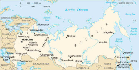
The coastline of Russia is longer than that of any other country in the world – almost 39 thousand kilometers. In total, the borders of Russia come into contact with the territories of 18 states, of which two are only partially recognized. This is Abkhazia and South Ossetia. Of all the border countries, only with two borders run exclusively by water, with Japan and the USA. Russia has maritime borders with 13 countries.
The longest of the borders of Russia divides our country and Kazakhstan. Its length reaches almost 7600 kilometers. Followed by China and Mongolia – 4200 and 3500 kilometers respectively. The borders of Russia pass through almost all existing climatic zones, from subtropics to arctic deserts. Russia and the United States divides only 4 kilometers in the Bering Strait.
The longest border of Russia within one region lies along the Arctic Ocean, its length is more than 19.7 thousand kilometers. In Belarus there is the Sankovo-Medvezhie enclave, a piece of Russian territory, surrounded on all sides by Belarusian lands.