Trying to answer the question: where is Everest and in which country – you will need to tell a lot. Everest is located in the Himalayas, everyone knows this. But not many people know what they are.
And it is not easy with Everest itself, since the immediate peak of Everest is located in China, but you can get to it not only from China. After all, the base of the mountain is located on the territory of two countries – Nepal and China. Accordingly, the conquest routes go from different directions.
In the southern part of central Asia, north of the Bay of Bengal, separating the Hindustan and Indochina peninsulas, there is a huge mountain range that is the highest on the entire planet.
This is the Himalayas, where 10 of the 14 highest mountains in the world are located, whose height exceeds eight thousand meters. The other four eight-thousanders are located in the Karakoram system, which adjoins Tibet from the western side. Both mountain systems of the Himalayas and Karakorum include several mountain ranges that are located simultaneously in different countries and are the borders of their territories. In the Himalayas, these are the ranges: Mahalangur-Himal, Kanchenjunga, Dhaulagiri, Manaslu, Nangaparbat, Annapurna and Langtang. On different sides of insurmountable ridges lived not only people of different nationalities, but also different ways of life, different faiths and speaking different languages. And naturally, they called their “own” mountains in their own way, without even thinking that people living on the other side gave them “their” names.
This happened with the largest mountain range “Mahalangur-Himal” on one side of which lived the Nepalese, and on the other the Tibetans. Moreover, both Nepalese and Tibetans, not even knowing that between them is the highest mountain range and the highest mountain in the world, deified this peak. The Tibetans called her the Jomolungma, which means “Holy Mother” or “Goddess is the mother of the Earth”, this name was given to her by the name of Sherab Chzhamma, the goddess of the national religion of Tibetans. Nepalese called the mountain “Jomo Kang Kar”, which means “Lady of the White Snows.”
Where is Mount Everest?
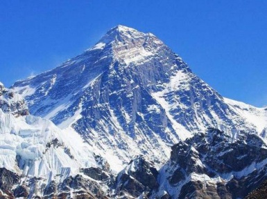
Everest is nothing more than the highest part of the Mahalangur-Himal mountain range, a mountain range called Khumbu-Himal. And these are several peaks, the two highest of which are the main ones.
The southern peak of Everest is 8760 m high, located on the border of Nepal and Tibet The northern peak of Everest – 8848 m high, located in China
Oddly enough, it’s quite difficult to understand where Everest is, even being almost in close proximity to it. This is due to the fact that Everest is surrounded by the highest peaks. Itself – the main, northern peak of Everest has the shape of a trihedral pyramid. Its southern slope is steeper, therefore, fresh snow and even last year’s blackened, called firn, do not linger on the very slope and its ribs, so this side is usually exposed. The height of the Northeast ridge is 8393 meters.
On the southern side of Everest, through the South Saddle Pass 7906 m high, there is Lhotse peak – 8516 meters, which is sometimes mistakenly called the Southern peak. From the north, behind the steep Northern saddle with a height of 7020 m, is Changze peak – 7543 meters. In the east of the massif is a completely impassable steep steep wall of Kangshung – it is 3350 meters of almost sheer cliffs. The height of Everest from the foot to the top is exactly the same – 3550 meters. Glaciers descend from the massif in all directions, ending at an altitude of about 5 km. Part of the Jomolungma located in Nepal is part of the Sagarmatha National Nepalese Park.
The name of the highest mountain in the world
It is noteworthy that the name of the highest mountain in the world – Chomolungma – was written for the first time recorded on a map in 1717. This map was made by French Jesuit missionaries who in those days visited Tibet. However, the map was a sketchy map, it did not have elevation marks and was not widely publicized, and the name Chomolungma did not attract the attention of geographers of that time.
The European name of the mountain – Everest, appeared much later. At the beginning of the 19th century, in India, the then British colony, the Royal Geographical Society began to conduct thorough geodetic surveys. George Everest served in the British East India Company conducting this survey. Having dedicated his service for more than 37 years from 1806 to 1843 as the chief surveyor of India, George Everest practically from scratch created Indian surveying and cartography. For which in 1827 he became a member of the Royal Geographical Society. Colonel George Everest returned to his homeland in 1843 and continued to work in the Royal Geographical Society. For special merits in 1861 he was awarded the title of knight. And from 1862 to 1865 he was vice president of the Royal Geographical Society.