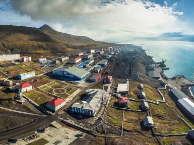
The Russian part of Svalbard is a territory on the island of Western Svalbard with an area of 251 square kilometers, which includes three coal deposits, mines and urban-type settlements: Barentsburg, Kolsbey, Pyramid and Grumantbyen.
Part of Svalbard is assigned to Russia on the basis of the Svalbard treatise, after the First World War in 1920. Currently, about 600 people live in the Russian part of Svalbard.
The Russian part of Spitsbergen was mastered by Russians at the end of the XV, at the beginning of the XVI century. Since then, the remains of their small buildings and lodges, which at that time were used only by Russian Pomors, were preserved there. Basically, these were sea hunters who came to the shores of Grumant, so this land was called then. In those days, the waters at the junction of the Atlantic and the Arctic Oceans abounded with whales, and on the rocky islands they arranged their huge rookeries of walruses and seals.
After the Dutch navigator Willem Barents visited these parts, in 1596 he plotted these islands under the name Svalbard. And although on Russian maps of an earlier time, these islands were listed as “Holy Russian islands”, but since Russia was not yet significant in the world of maritime powers, the name Svalbard was officially established throughout the world.
Whalers of all marine European countries came to these northern waters behind the whale, but the Dutch were especially zealous for this, who killed hundreds of whales during the season. As a result, by the beginning of the 19th century, the number of whales in these waters had decreased so much that it became rare to see a whale, and interest in these bare rocky islands began to disappear.
But this changed the fact that coal was discovered on Svalbard. The discovery of coal is attributed to the English whaler Pull, who discovered coal in 1610 on the northwest coast of Svalbard, on the shore of Kings Bay, in the course of a frozen stream and began to use it for smelting whale oil. However, there is evidence that the coal coming to the surface, even before it, was used by the Russian Pomors remaining for the winter on Grumant.
In addition, Svalbard was quite far away, in harsh northern conditions, and this discovery was not in demand for a long time. But with the development of shipping in the XIX century, industrialists got there. In the 60-70s of the XIX century, geologists revealed that there is a lot of coal on Svalbard. Entrepreneurs of England, America, Norway, Holland, Germany began to actively conduct exploration of coal deposits and its trial mining. In 1906, John Longyearbyan, a native of America, opened the first coal mine on Spitsbergen and organized industrial coal mining.
Russia also did not stand aside. Svalbard was of great interest as a source of coal for the northern regions. In addition, due to its geopolitical location, at the junction of the Atlantic and the Arctic oceans, Svalbard could serve as a base for the military and merchant Russian fleet.
To begin the development of Svalbard, the Russian government agreed with the Swedish government to conduct its survey by the efforts of two Academies of Sciences: the Russian and the Swedish. As a result of this agreement, a joint Russian-Swedish expedition was organized on Spitsbergen, led by a world-famous Russian scientist Theodosius Nikolaevich Chernyshev. For the expedition, the newly built world’s first Arctic icebreaker Ermak was allocated.
For three years from 1899 to 1901, the Chernyshev expedition studied the Spitsbergen archipelago, the results of which were: a description of its landscape and geology, elevations of land and depth of the fjords, astronomical and geodetic, magnetic, meteorological, geological, hydrological, hydrographic observations, research auroras. More than two-thirds of all studies were conducted by the Russian part of the expedition.
The results of the Chernyshev expedition are still used. Chernyshev himself, due to his long stay in extreme conditions, severely undermined his health. The name of the Russian academician F.N. Chernyshev is carried by several geographical objects on the maps of the World, including the mountain on Svalbard, on top of which, as a triangulation sign, the expedition participants made a stone pyramid, the so-called “stone signal”, which has survived to this day. since
The bureaucracy of then-Russia was so great that for the practical development of Svalbard only in 1911 an expedition was sent to Svalbard to make geological surveys. The Ministry of Finance allocated as much as 4 thousand rubles for this expedition. The expedition was headed by V.F.Drzhevetsky, the captain of the vessel was V.N. Serebrennikov. For the expedition, a private two-masted sailing vessel, Jacques Cartier, was chartered, which sailed from Arkhangelsk on August 8, 1911.